


Voting District 0007, Rains County, Texas
About
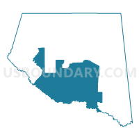
Outline

Summary
| Unique Area Identifier | 676460 |
| Name | Voting District 0007 |
| County | Rains County |
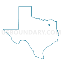
| State | Texas |
| Area (square miles) | 61.06 |
| Land Area (square miles) | 60.15 |
| Water Area (square miles) | 0.91 |
| % of Land Area | 98.51 |
| % of Water Area | 1.49 |
| Latitude of the Internal Point | 32.80984080 |
| Longtitude of the Internal Point | -95.81138150 |
Maps

Graphs
Select a template below for downloading or customizing gragh for Voting District 0007, Rains County, Texas


Neighbors
Neighoring Voting District (by Name) Neighboring Voting District on the Map
- Voting District 0001, Rains County, TX
- Voting District 0002, Rains County, TX
- Voting District 0005, Rains County, TX
- Voting District 0006, Van Zandt County, TX
- Voting District 0010, Van Zandt County, TX
- Voting District 0010, Rains County, TX
- Voting District 0011, Rains County, TX
- Voting District 0013, Van Zandt County, TX
- Voting District 0020, Van Zandt County, TX
Top 10 Neighboring County Subdivision (by Population) Neighboring County Subdivision on the Map
- Wills Point CCD, Van Zandt County, TX (9,373)
- Grand Saline CCD, Van Zandt County, TX (8,229)
- Emory CCD, Rains County, TX (6,398)
- Edgewood CCD, Van Zandt County, TX (4,749)
- Point CCD, Rains County, TX (4,516)
Top 10 Neighboring Place (by Population) Neighboring Place on the Map
Top 10 Neighboring Unified School District (by Population) Neighboring Unified School District on the Map
- Wills Point Independent School District, TX (13,716)
- Rains Independent School District, TX (10,518)
- Grand Saline Independent School District, TX (6,744)
- Edgewood Independent School District, TX (5,151)
- Fruitvale Independent School District, TX (1,675)
Top 10 Neighboring State Legislative District Lower Chamber (by Population) Neighboring State Legislative District Lower Chamber on the Map
Top 10 Neighboring State Legislative District Upper Chamber (by Population) Neighboring State Legislative District Upper Chamber on the Map
Top 10 Neighboring 111th Congressional District (by Population) Neighboring 111th Congressional District on the Map
Top 10 Neighboring Census Tract (by Population) Neighboring Census Tract on the Map
- Census Tract 9501, Rains County, TX (6,398)
- Census Tract 9504, Van Zandt County, TX (4,880)
- Census Tract 9501, Van Zandt County, TX (4,853)
- Census Tract 9503, Van Zandt County, TX (4,749)
- Census Tract 9502, Rains County, TX (4,516)
Top 10 Neighboring 5-Digit ZIP Code Tabulation Area (by Population) Neighboring 5-Digit ZIP Code Tabulation Area on the Map
- 75169, TX (14,644)
- 75140, TX (6,958)
- 75440, TX (6,350)
- 75410, TX (4,334)
- 75117, TX (3,722)
- 75472, TX (3,548)
- 75127, TX (1,593)